This article is a reprinted article. The original title is: "Analisis Gempa Bumi Laut Banda 8 November 2023". The author is Muhammad Al Kautsar. It comes from https://www.big.go.id/. The original link is: https://www. big.go.id/en/content/artikel/analisis-gempa-bumi-laut-banda-8-november-2023.
At 04:53:30 UTC on November 8, 2023, a magnitude 7.1 event occurred in the Banda Sea region of Indonesia (6.453°S, 129.517°E), with a focal depth of 10 kilometers. The real-time BDS/GNSS positioning system, GSeisRT, developed by the PRIDE group at Wuhan University and installed at the Geospatial Information Agency of the Republic of Indonesia, successfully captured this event.
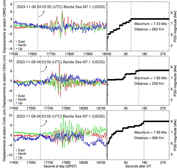
The figure below shows the real-time seismic displacement waveforms captured by the CUAL, CSAU, and CBNG stations in the online earthquake monitoring system. The distances from the stations to the epicenter are 263 kilometers, 259 kilometers, and 368 kilometers, respectively. Based on the displacement waveforms captured by the CBNG station and the Peak Ground Displacement (PGD) magnitude function, the real-time magnitude is estimated to be approximately 7.43, which is only 0.33 magnitude units different from the standard magnitude reported by the USGS. This validates the efficiency and reliability of the GSeisRT in rapidly determining earthquake magnitudes, even at significant distances from the epicenter and under the influence of seismic wave resonance.

Real-time captured seismic waveforms and estimated magnitudes at the CBNG, CSAU, and CUAL stations
Copyright PRIDELAB IN GNSS CENTER , Wuhan University Visits:242106 Powered by Truesing