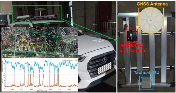
With the development of smart transportation, autonomous driving, mobile measurement and other fields, the demand for positioning and navigation is increasing for devices such as vehicles, drones and smartphones, and navigation application scenarios are becoming more and more complex, with higher requirements for positioning accuracy and reliability. In most scenarios, Global Navigation Satellite System (GNSS) can provide users with highly accurate and reliable location information. But in scenarios such as tunnels, tree-lined areas, urban canyons, indoor places and strong electromagnetic interference places, GNSS performance drops dramatically, even failing to provide or providing incorrect positioning information, making it difficult to adapt to the current complex and changeable location service scenarios. To obtain robust navigation performance, GNSS is often integrated with an Inertial Measurement Unit (IMU) to form a GNSS/INS integrated navigation system, which is used in navigation and positioning. In environments with poor GNSS observation, the performance of GNSS/INS integrated navigation system is closely related to the level of the IMU. The higher the IMU level, the higher the positioning accuracy and the cost of the system. Although Micro-Electro-Mechanical Systems (MEMS) IMU for the mass market can improve GNSS positioning performance to some extent, it still cannot provide reliable navigation and positioning information consistently.
In addition to GNSS and IMU, there are still many sensors that can be used for navigation and positioning, such as LIDAR, cameras, magnetometers, barometers, etc. Therefore, in order to address the constraints of the inherent weaknesses of GNSS and provide reliable navigation information in GNSS-denied environment, in 2010, the US Defense Advanced Research Projects Agency (DARPA) proposed and conducted the research of All Source Position and Navigation (ASPN), that is, based on multi-source sensors, according to the changing mission requirements, fast system reconfiguration, online configuration and plug-and-play integrated navigation system are realized. The ASPN system, which includes GPS, IMU, camera, magnetometer, and barometer, was successfully developed by the US Air Force Research Laboratory in May 2017 and has been tested in multiple field experiments on air, sea and land platforms.
The research on all source integrated navigation started late in China and is still in the exploration stage. Our team is working on all source navigation research. We have built an unmanned vehicle experimental platform containing sensors such as GNSS, IMU, monocular/binocular/fisheye cameras and LIDAR, designed and developed the software platform of GNSS/INS/Vision tight integrated positioning algorithm independently, and tested the hardware and software platform in the real environment of city blocks. In the subsequent research, we will integrate more sensors and further optimize the software platform to promote the development of all source integrated navigation in China.

Copyright PRIDELAB IN GNSS CENTER , Wuhan University Visits:241998 Powered by Truesing