PrideLab published their research on earthquake magnitude determination with GNSS observations.
Rapid estimation of earthquake magnitude is an important prerequisite for earthquake early warning, post-earthquake rapid response and tsunami early warning. In recent years, with the development of high-rate GNSS receiver technology and the improvement of accuracy of GNSS positioning and velocity measurement, GNSS technology has been widely used in earthquake real-time monitoring, earthquake magnitude estimation, earthquake early warning and so on.
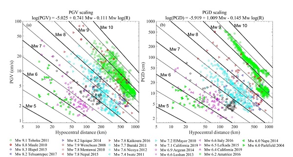
Precise point positioning technology relies on precise satellite orbit and clock products, and it also requires a relatively long convergence or re-convergence time of around 20-30 minutes to achieve centimeter-level positioning accuracy, which is intolerable for the continuous, real-time and high-accuracy dynamic deformation monitoring in the real-time GNSS applications such as earthquake. To address this problem, this paper proposes a new method to estimate the surface wave magnitude of an earthquake in real time using the peak ground velocities derived by high-rate GNSS observations. The method can obtain GNSS velocity time series in millimeters per second by using variometric algorithm and extract three-dimensional PGVs from GNSS velocity waveform. This paper also adopts 1434 GNSS seismic records (1Hz) of 22 seismic events ranging from Mw 6.0 to Mw 9.1 to obtain the empirical relationship between PGVs and surface wave magnitude based on the principle of robust least squares.
In order to verify the applicability and reliability of the PGVs surface wave magnitude method, it is compared with the surface wave magnitude method based on the peak ground displacements. The results show that the magnitude average absolute deviation of the PGVs method is 0.26 magnitudes with the USGS moment magnitude as the reference value, which is similar to the results of PGDs method. Further, in order to verify the application performance of GNSS PGVs in the rapid generation of post-earthquake intensity map, the MMI(Modified Mercalli Intensity)derived by GNSS PGVs are compared with USGS(U.S. Geological Survey)ShakeMap products. The results show that there is good agreement between the two sides. In summary, GNSS PGVs can be used as a powerful supplement to earthquake data, especially in areas with sparse seismic station coverage for large earthquake.
For more details, please refer to the paper: Fang, R., Zheng, J., Geng, J., Shu, Y., Shi, C., & Liu, J. (2020). Earthquake Magnitude Scaling Using Peak Ground Velocity Derived from High-Rate GNSS Observations. Seismological Research Letters. https://doi.org/10.1785/0220190347

Figure 3. (a) Peak ground velocity (PGV) measurements with hypocentral distance. Oblique lines are the predicted scaling values from the regression analysis of the PGV measurements as a function hypocentral distance. (b) Peak ground displacement (PGD) measurements with hypocentral distance. Oblique lines are the predicted magnitudes as a function of PGD and hypocentral distance following the scaling law of equation (3).
Copyright PRIDELAB IN GNSS CENTER , Wuhan University Visits:172281 Powered by Truesing